Long Distance Series Product Model

2023-03-25
Vehicle-to-infrastructure cooperation ultimately requires the improvement of the "intelligent level" of both vehicles and roads in order to achieve safe autonomous driving. In other words, the intelligence of vehicle-to-infrastructure cooperation is another process of realizing unmanned driving. The specific breakdown of intelligentization is the upgrade of intelligent devices and algorithms covering vehicles and roads, with sensors being the most important intelligent devices.
LiDAR is the core perception sensor for vehicle-based unmanned driving, as well as the roadside sensor for roadside units. Through 5G and other communication methods, it provides traffic environment information for vehicles. So, what does Lidar need to do to complete the mission on the road?
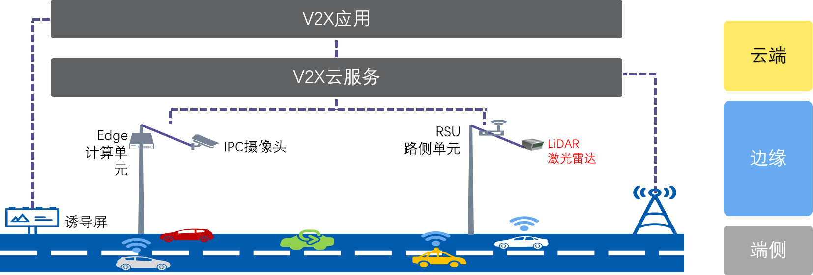
Figure 1: Schematic Diagram of the Vehicle-road Cooperative System Coordination
I. Mission of LiDAR
Safe and intelligent driving is an inevitable topic for both vehicles and roads. In vehicle-road cooperative systems, LiDAR not only need to perceive the complete and accurate status of various vehicles, personnel, and infrastructure in the traffic environment but also need sufficient safety redundancy to deal with problems caused by various "long-tail effects". In fact, true vehicle-road cooperation is no less challenging than autonomous driving.
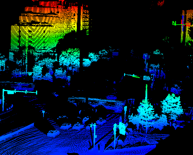
Figure 2: Point Cloud Effect of Benewake Horn Series LiDAR Detecting Crossroads
II. Why LiDAR is Chosen
The main disadvantage of cameras is their dependence on lighting conditions, which results in a high error rate in poor lighting or strong light interference. The detection distance is affected by the lighting, resulting in lower accuracy, and using a single camera for roadside calculations requires extremely powerful computing power, with bandwidth and real-time constraints in signal transmission and processing. The main drawback of millimeter-wave radar is that it hardly receives any echoes from completely stationary objects and is prone to false alarms in environments with certain metal interference. Although LiDAR uses optical principles, it is not dependent on environmental light, works 24h a day, greatly enhancing its perceptual adaptability, and enhancing the accuracy of detection by improving the 3D detection of the target object, capturing both static and dynamic objects.
Roadside scenes are extremely complex, especially at busy intersections. In fact, relying solely on one technology will pose safety risks due to false positives and misses, making it difficult to achieve stable intelligent detection of road conditions. By fusing LiDAR and cameras, information such as the position, distance, size, speed, direction, and color of an object can be obtained in one go.
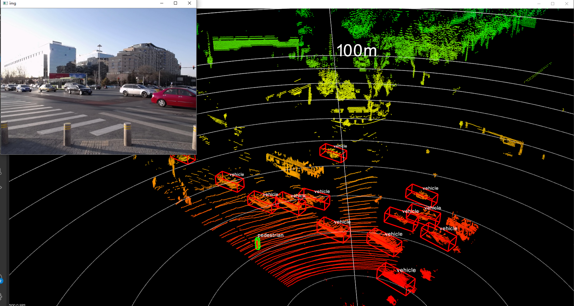
Figure 3: Benewake Horn Series LiDAR Recognizes Vehicles and Pedestrians at Crossroads
1. Strong data collection capability
① Far detection distance
The effective range of the mechanical rotating LiDAR is generally between 150 to 200 meters. However, the Northiing Horn LiDAR series, which uses 1550nm eye-safe lasers, can detect up to 300 meters. This distance reduces the hardware cost and construction pressure when wiring on the roadside.
②High Resolution
The line numbers of the common LiDARs on the market are mainly 16, 32, and 64, and the associated parameter is the resolution. Both image-level LiDARs and digital LiDARs increase the line number to make later algorithms easier and reduce the difficulty of the perception level. In order to solve the problem of detecting small targets at long distances, Benewake and other LiDAR manufacturers have increased their resolution to 300-600 lines. For vehicle-road coordination applications, the high resolution can quickly identify various types and quantities of targets on the road.
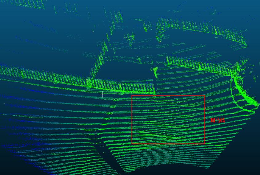
Figure 4: Zebra Crossings Detected by Benewake Horn Series LiDAR
Small targets are difficult to detect with LiDAR because the light emitted by the LiDAR is hard to be reflected back due to the small size of the target. The resolution is mainly determined by the vertical angle resolution. The smaller the value of the vertical angle resolution, the more points can be detected, and the clearer the detection, especially for small targets. As shown in the figure below, there are more points in the vertical direction and the number of point clouds is greater.
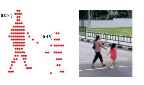
Figure 5: Comparison of Pedestrian Point Clouds with Vertical Resolutions of 0.05° and 0.1° at Equal Distances
In terms of vertical angle resolution, Benewake LiDAR can achieve a vertical angle resolution of up to 0.05°, which is 9.4 times that of a 64-line LiDAR. It can accurately detect small targets at long distances, and its actual detection and recognition ability for pedestrians can reach 115 meters, while a 64-line LiDAR has a lower beam and its actual detection and recognition ability is only within 12 meters.
Table 1. Relationship Between Equivalent Number of LiDAR Lines and Maximum Recognition Distance of Small Objects (0.1m)

③Wide field of view angle
The coverage area of a camera installed at an intersection is generally only about 10°, with a narrow field of view. The 360-degree mechanical rotating LiDAR undoubtedly has a wider field of view, but its internal rotating structure has always been questioned for its lifespan. Benewake Horn LiDAR series does not adopt a mechanical coaxial rotating structure and has a horizontal field of view angle of 90°, with a detection range far greater than that of a camera. One device can cover a large scene of 300m*300m. Therefore, the number of LiDARs installed to detect the same intersection will be far less than the number of cameras. The LiDAR solution is more suitable for detecting red light running areas with a large field of view than a single camera solution.
2. Ability to fuse data
①Integration with cameras and other sensors
A single camera solution can only provide two-dimensional information, and in strong or backlit conditions, the shooting and detection effect is easily invalidated. Especially in the absence of ambient light at night, the camera solution is basically ineffective. The point cloud provided by traditional mechanical LiDAR is very sparse, especially after being installed on the road, very few effective points are collected, making it difficult to fuse with other sensors.
Benewake LiDAR can provide more than 2.8 million points per second, with a maximum point cloud output of 1800*600, which is easy to fuse with cameras. Such a combination can achieve obstacle avoidance, deceleration, and bypassing by tracking pixels, which is undoubtedly a new opportunity for autonomous driving and assisted driving.
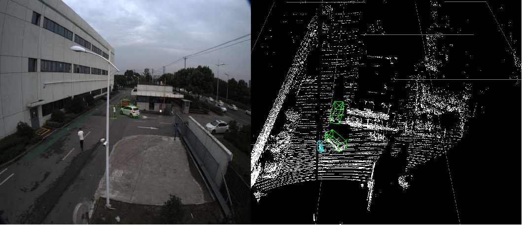
Figure 6: Fusion Data of Point Cloud and Camera (Left)
Point Cloud Data (Right)
3. Simple Deployment Solution
①Support for customer deployment solutions
In the vehicle-road coordination application, Benewake will provide customers with support to showcase the point cloud perception function of the Horn LiDAR series. Based on Benewake 3D point cloud, various transmission protocols will be provided to assist customers to quickly implement and deliver projects and achieve functions such as pedestrian red light crossing alarms, vehicle collision warnings, and illegal behavior capture.
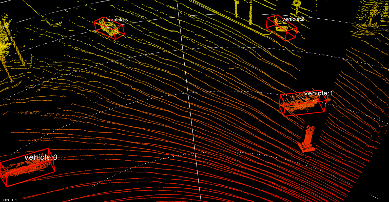
Figure 7: Vehicle Recognition Based on Benewake LiDAR
②Installation and Deployment
For the LiDAR installed on the road, it is usually mounted on the cross beam of a high pole around 6-7 meters high, such as a utility pole or a traffic enforcement pole. The installation position is generally close to the center of the road, as shown in Figure 8. Benewake Horn series LiDAR has a long detection distance and a wide field of view angle, and one device can simultaneously detect targets on different lanes in both directions of the road. For LiDARs with smaller field of view angles, at least two or more devices need to be installed.
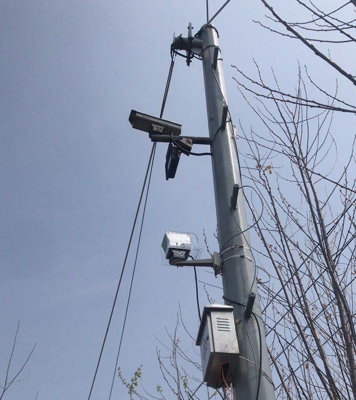
Figure 8: Benewake Horn Series LiDAR Roadside Installation Method
4. Easy to integrate and mass-produce
Due to the continuous mechanical rotation of the entire optical and electronic module of the 360° mechanical rotating LiDAR during operation, the components are prone to wear and tear. Furthermore, each transmitter and receiver photodetector's field of view angle needs to be corresponded manually during the LiDAR assembly process, which is not conducive to automated production and makes mass production difficult.
In the market, a 32-line LiDAR is relatively mature and has good performance. The price per unit is around $40,000 with several thousand kits shipped. Benewake LiDAR adopts optical integrated design to achieve small and lightweight products and implement mass production by laying out the entire transportation industry, thereby greatly reducing costs. In the vehicle-road coordination application, the total cost can be reduced more quickly by considering the number of installations and software capabilities.
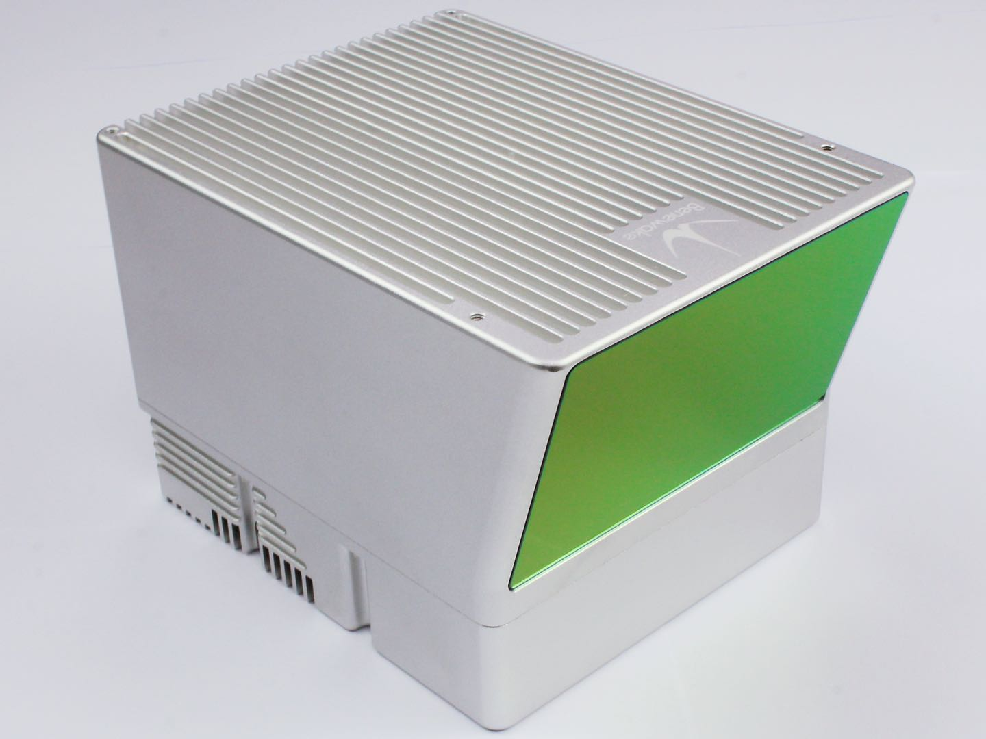
Figure 9: Real-life Picture of Benewake Horn-X2 LiDAR
III. Typical Functions
Urban roads
Safety warnings for pedestrians and vehicles
Traffic violation detection
Vehicle flow statistics
Comprehensive traffic monitoring and command management
ETC highway Triggered capture
Vehicle information detection
Abnormal event warning
Traffic monitoring and management
Please feel free to inquire or leave a message via the backend:
Phone: 400-880-9610
Email: bw@benewake.com
