Home
Products
Single-point..
Short Distance Series Product Model
TF-UW500
TF-UW500
Learn More
Add to Comparison
Dimensions (L*W*H)
24mm×16mm ×20.4mm
Interface
UART, I²C
Protection Level
without enclosure
Range
> 5 m
Frame Rate
20Hz
Power Consumption
< 5V × 100mA
Weight
< 5 g
TF-NOVA
TF-NOVA
Learn More
Add to Comparison
Dimensions (L*W*H)
26.5 mm × 21.05 mm × 12 mm
Interface
UART, I/O, I²C
Protection Level
without enclosure
Range
14 m
Frame Rate
1 ~ 900 Hz
Power Consumption
TBD
Weight
< 5 g
TF-Luna
TF-Luna
Learn More
Add to Comparison
Dimensions (L*W*H)
35 mm × 21.25 mm × 13.5 mm
Interface
UART, I/O, I²C
Protection Level
without enclosure
Range
0.2 ~ 8 m
Frame Rate
1 ~ 250 Hz
Power Consumption
≤ 0.35 W
Weight
< 5 g
TFmini-S
TFmini-S
Learn More
Add to Comparison
Dimensions (L*W*H)
42 mm × 15 mm × 16 mm
Interface
UART, I/O, I²C
Protection Level
IP65
Range
0.1 ~ 12 m
Frame Rate
1 ~ 1000 Hz
Power Consumption
≤ 0.7 W
Weight
5 ± 0.3 g
TFmini Plus
TFmini Plus
Learn More
Add to Comparison
Dimensions (L*W*H)
35 mm × 18.5 mm × 21 mm
Interface
UART, I/O, I²C
Protection Level
IP65
Range
0.1 ~ 12 m
Frame Rate
1 ~ 1000 Hz
Power Consumption
550 mW
Weight
12 ± 1 g
TFmini-i
TFmini-i
Learn More
Add to Comparison
Dimensions (L*W*H)
50 mm × 34 mm × 41 mm
Interface
CAN, RS-485
Protection Level
IP65
Range
0.1 ~ 12 m
Frame Rate
1 ~ 1000 Hz
Power Consumption
≤ 0.8 W @ 12 V
Weight
52 g
TFS20-L
TFS20-L
Learn More
Add to Comparison
Dimensions (L*W*H)
21 mm × 15 mm × 7.87 mm
Interface
UART, I²C
Protection Level
without enclosure
Range
0.2 ~ 20 m
Frame Rate
1 ~ 250 Hz
Power Consumption
≤ 0.35 W
Weight
~ 1.35 g
Medium Distance Series Product Model
TF02-Pro
TF02-Pro
Learn More
Add to Comparison
Dimensions (L*W*H)
69 mm × 41.5 mm × 26 mm
Interface
UART, I/O, I²C
Protection Level
IP65
Range
0.1 ~ 40 m
Frame Rate
1 ~ 1000 Hz
Power Consumption
≤ 1 W
Weight
50 g
TF02-i
TF02-i
Learn More
Add to Comparison
Dimensions (L*W*H)
69 mm × 40.5 mm × 31.25 mm
Interface
CAN, RS-485
Protection Level
IP65
Range
0.1 ~ 40 m
Frame Rate
1 ~ 1000 Hz
Power Consumption
≤ 0.85 W @ 12 V
Weight
60 g
TF02-Pro-W
TF02-Pro-W
Learn More
Add to Comparison
Dimensions (L*W*H)
85 mm × 59 mm × 43 mm
Interface
UART, RS-485, I/O, I²C
Protection Level
IP5X
Range
0.1 ~ 25 m
Frame Rate
1 ~ 1000 Hz
Power Consumption
≤ 2 W
Weight
90 ~ 92 g
Long Distance Series Product Model
TFA170-L
TFA170-L
Learn More
Add to Comparison
Dimensions (L*W*H)
31.0 mm × 30.2 mm × 19.2 mm
Interface
RS-232
Protection Level
without enclosure
Range
0.1 ~ 170 m
Frame Rate
1 ~ 1000 Hz
Power Consumption
≤ 1 W
Weight
~ 10 g
TF03
TF03
Learn More
Add to Comparison
Dimensions (L*W*H)
44 mm × 43 mm × 32 mm
Interface
UART, CAN, RS-232, RS-485
Protection Level
IP67
Range
0.1 ~ 180 m
Frame Rate
1 ~ 9800 Hz
Power Consumption
≤ 1 W
Weight
86 ± 3 g
TFA300 Series
TFA300 Series
Learn More
Add to Comparison
Dimensions (L*W*H)
49.4 mm × 37.0 mm × 28.6 mm
Interface
UART, CAN
Protection Level
IP67
Range
0.1 ~ 290 m
Frame Rate
1 ~ 10,000 Hz
Power Consumption
≤ 0.45 W
Weight
10.5 g
TF350
TF350
Learn More
Add to Comparison
Dimensions (L*W*H)
78 mm × 67 mm × 40 mm
Interface
UART, CAN, RS-232, RS-485
Protection Level
IP67
Range
0.2 ~ 350 m
Frame Rate
1 ~ 1000 Hz
Power Consumption
≤ 1 W
Weight
224 ± 3 g
Kilometer-level
TFA1200-L
TFA1200-L
Learn More
Add to Comparison
Dimensions (L*W*H)
25 mm × 25 × 13 mm
Interface
UART
Protection Level
without enclosure
Range
3 ~ 1200 m
Frame Rate
3 Hz
Power Consumption
< 1.1 W
Weight
11 g
TFA1500-L
TFA1500-L
Learn More
Add to Comparison
Dimensions (L*W*H)
≤ 25 mm × 26 mm × 13 mm
Interface
UART
Protection Level
without enclosure
Range
0.5 ~ 1500 m
Frame Rate
60 ~ 800Hz (adaptive)
Power Consumption
≤ 1.8W
Weight
11 g
2D Series..
VLS Series
VLS-H5
VLS-H5
Learn More
Add to Comparison
Dimensions (L*W*H)
52.0 mm × 75.0 mm × 53.1 mm
Interface
UART
Protection Level
IPX8
Range
5 m
Frame Rate
6 Hz
Power Consumption
Weight
125g
TR Series
TR Serise
TR Serise
Learn More
Add to Comparison
Dimensions (L*W*H)
60 mm × 60 mm × 80 mm
Interface
Protection Level
IP65
Range
40 m
Frame Rate
10 ~ 30 Hz
Power Consumption
Weight
3D Series..
Long Distance Series Product Model
LR10 series
LR10 series
Learn More
Add to Comparison
Dimensions (L*W*H)
92 mm × 47 mm × 51 mm
Interface
Ethernet, GMSL, I/O
Protection Level
IP67
Range
0.05-18m
Frame Rate
10fps
Power Consumption
Weight
460g
AD2-S-X3
AD2-S-X3
Learn More
Add to Comparison
Dimensions (L*W*H)
49 mm × 160 mm × 144 mm
Interface
1000Base-T1 Automotive Ethernet
Protection Level
IP67 & IP6K9K
Range
300 m @ 10%
Frame Rate
10 Hz
Power Consumption
≤ 15 W
Weight
1.2 kg
Horn-X2 Pro
Horn-X2 Pro
Learn More
Add to Comparison
Dimensions (L*W*H)
192.6 mm × 157 mm × 126 mm
Interface
1000Base-T
Protection Level
IP67
Range
300 m @ 10%
Frame Rate
1 ~ 20 FPS
Power Consumption
≤ 35 W
Weight
≤ 3.8 kg
Horn-RT
Horn-RT
Learn More
Add to Comparison
Dimensions (L*W*H)
183 mm × 157 mm × 120 mm
Interface
1000Base-T
Protection Level
IP67
Range
300 m @ 10%
Frame Rate
1 ~ 20 FPS
Power Consumption
≤ 35 W
Weight
≤ 3.3 kg
Applications
Autonomous Mobility
ADAS
Unmanned Mining Trucks
Smart Logistics - Last-Mile Unmanned Delivery
Autonomous Driving Truck Operation
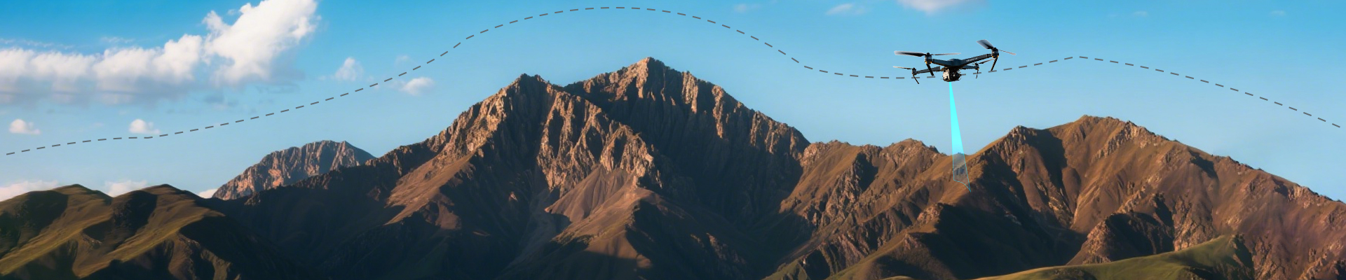
UAV
Terrain Following
Position Hold
Level Detection
Level Detection
Volume Detection
Liquid level measurement
Space & People Flow Detection
Robot
Pallet Transport Robot Obstacle Avoidance
Crane Positioning / Obstacle Avoidance
Robot Fall Prevention & Obstacle Avoidance
Smart Transportation
Vehicle Door Obstacle Avoidance
Smart Parking
Automotive Electric Tailgate
Highway Key Area Monitoring
V2X / Holographic Intersection / Traffic Light Control
Meli train collision avoidance system
Smart Civil Aviation
IoT
Auxiliary Focus
Smart Trigger
Security Warning
Rotary door anti-clamping
Blind cane
Download
About Us
Distributors
News
Contact Us
bw@benewake.com
中
EN
Contact
UAV
Terrain Following
Laser rangefinder provides highly reliable absolute distance data with centimeter-level accuracy
Position Holding//Hovering
Laser rangefinder with a divergence angle of less than 0.5°, can accurately target fine structures smaller than 10 cm at distances beyond 10 meters
Gimbal Rangefinding
Gimbal integrated LiDAR for intelligent focused tracking and relative object positioning
Stable-altitude Cruising
Maintain centimeter-level stability while cruising and hovering at altitudes above 200 meters
Detect and Avoid
Ensure safety by detecting obstacles in real time and assists flight controllers in taking evasive measures
Your Drone Pain Points, Solved
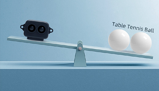
As Light as 5g Extended Operation Endurance
Miniaturization Increased Payload Capacity
Integrated Rain-Fog Algorithm Strong Environmental Adaptability
Long Range Remote Assisted Focus
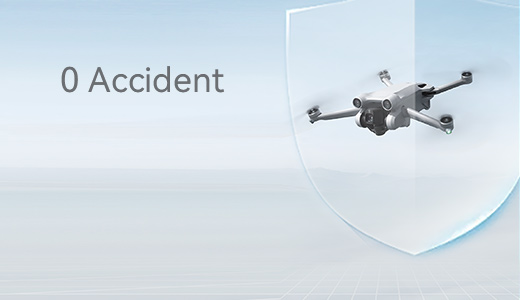
Million Units Shipped Mass Production Quality Assurance
DO-160G Certification Reliability & Safety
How Benewake Addresses the Pain Points
Light weight to 5g
Compact design
More compact with high integration
Market-proven product
DO-160G
Capable of passing DO-160G certification, allowing it to withstand various harsh airborne environments
Core Functions
01
Terrain following/holding
Provide highly reliable absolute distance data with centimeter-level accuracy
02
Position hold
With a divergence angle of less than 0.5°, can accurately target fine structures smaller than 10 cm at distances beyond 10 meters
03
Autonomous takeoff and landing
Can perfectly meet the high-precision measurement requirements for autonomous takeoff and landing in the critical distance range
04
Depth perception and pinpoint
Can provide real-time measurements of target objects as small as 1.5 meters from 170 meters away
Customers Case
Drone with Pod/Gimbal
Logistic Drone
Product Recommendations
TF-Luna
0.2 ~ 8 m
1 ~ 250 Hz
≤ 0.35 W
< 5 g
UART,I/O,I²C
TF02-Pro
0.1 ~ 40 m
1 ~ 1000 Hz
≤ 1 W
50 g
UART,I/O,I²C
TFA170-L
0.1 ~ 170 m
1 ~ 1000 Hz
≤ 1 W
~ 10 g
RS-232
Home
Products
Applications
Download
About Us
bw@benewake.com
Headquarters:3rd Floor, Haiguo Jiaye Sci-Tech Park, Haidian District, Beijing, China
Official WeChat
Website map
Privacy Terms
Warranty terms
Benewake (Beijing) Co., Ltd. All Rights Reserved. Privacy Policy 版权所有 | 京ICP备17046746号-1. 京公网安备 11010802024472号
Leave a message
Tailor-made
Your own solution
Privacy Terms
Get Your Free Quote
bw@benewake.com
We use cookies to enhance your browsing experience and serve personalized content.
Reject ALL
Accept ALL