VLS Series
Long Distance Series Product Model

As air travel and cargo volumes increase, the civil aviation industry has a growing need to improve operational efficiency and ensure safety. Aircraft parking guidance systems and apron monitoring are essential components of improving civil aviation intelligence. The parking guidance system uses various sensors and computer vision technology to monitor and guide the aircraft's parking position in real-time, improving parking efficiency and reducing errors compared to traditional manual guidance. Apron monitoring can detect aircraft, vehicles, and personnel in real-time, quickly detecting and resolving safety hazards and ensuring safe and smooth operations.
Benewake's high-performance 3D LiDAR, with its ultra-high resolution and range, can provide azimuth guidance, aircraft type reference, flight information, taxiing speed, and parking signals for incoming aircraft. It can also detect 3D environmental information such as runways and elevation bands in the flight area, providing high-reliability perception capabilities to ensure the safety and operational efficiency of the aircraft operating area.
|
|
| ||
Ultra-long Range Capturing aircraft and specialized vehicles at 300m, and pedestrians at over 200m | Ultra-high Resolution 256 lines, allowing for precise detection of aircraft, vehicles, and pedestrians | Wide FoV Can simultaneously detect aircraft and jet bridges | ||
|
|
| ||
High Reliability Meets ASIL-B functional safety requirements, not affected by natural light conditions, no need for supplementary lighting, capable of all weathers | High Precision Accurately identifies similar aircraft models, vehicles, and people | Synchronized Multi-LiDAR Networking Supports various time synchronization methods such as gPTP, PTP, NTP, achieving microsecond-level synchronization. Friendly for feature extraction with 2 million point frequencies |
Comprehensive Perception of the Airfield
Leveraging Benewake's high-resolution and long-range 3D LiDAR, it's possible to achieve fine monitoring of aircraft, vehicles, and pedestrians in the airfield. This includes structured targets such as type (aircraft, vehicles, pedestrians), speed, heading angle, trajectory, etc., enabling precise monitoring of airfield elements.
Event Detection
Based on the motion status, trajectory, and posture of structured targets in the airfield, further analysis and prediction are conducted. Combined with technologies such as big data and artificial intelligence, this enables functions such as event warning, prediction, and decision support.
Apron Monitoring Projects at Tianfu International Airport and Beijing Capital International Airport

Airport docking guidance systems improve the accuracy of manual guidance, ensuring safe, efficient, and convenient completion of guiding tasks, indirectly reducing labor costs. They also assist airport management departments in calculating the occupancy time of each parking position, enabling the scheduling of more aircraft takeoffs and landings, effectively increasing the utilization rate of parking resources, enhancing safety, and reducing flight delays.
Benewake's high-performance three-dimensional LiDAR offers unique advantages, significantly enhancing the accuracy and safety of the entire system.
Large Scan Data Volume, Precise Docking
Using laser scanning to determine aircraft model, position, speed, and other parameters, with a measurement accuracy of less than 10cm. The pixel-level point cloud data with rich detail features enables precise identification of similar aircraft models, ensuring more accurate aircraft docking.
Fast Data Acquisition, Safe Docking
Real-time acquisition of full digital features makes information processing easy. The three-dimensional LiDAR can simultaneously scan jet bridges, vehicles, pedestrians, and obstacles and issue warnings, ensuring safe aircraft docking.
Strong Environmental Adaptability, All-Weather Operation
Active detection with strong environmental adaptability, capable of operating in all weather conditions without being affected by weather or environmental illumination.
Projects at Changsha Huanghua Airport, Nanyang Jiangying Airport, etc.

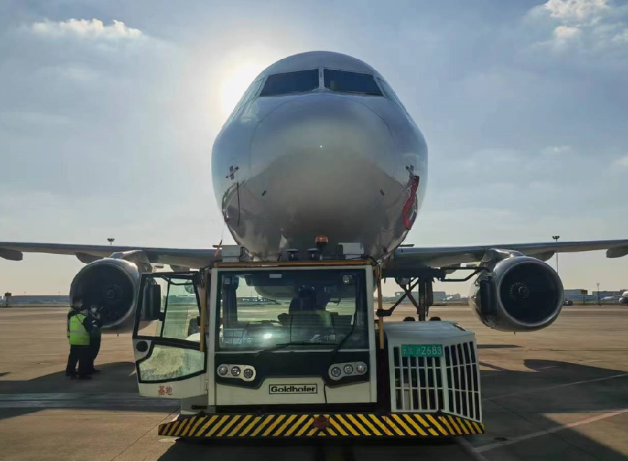
To ensure the safe operation of the towing process, it is essential to equip the towing vehicle with an advanced obstacle avoidance warning system. This system can quickly alert the towing driver, effectively preventing collisions with obstacles in the operating area, thereby significantly reducing the risk of accidents.
Based on Benewake's high-performance 3D LiDAR, the aircraft ground towing collision avoidance application can effectively detect obstacles in the vicinity of the aircraft during taxiing, relocation, and long-distance towing processes. This helps prevent injuries to personnel caused by collision accidents, greatly enhances operational safety, and reduces unforeseen property losses.
|
|
| ||
Ultra-Long Range A long range of 200m makes sure a large defense zone for the aircraft surroundings. | Ultra-High Resolution With 256 lines, equipped with the ability to perceive fire extinguishers within a range of 100m | Centimeter-Level Detection Accuracy ±3cm accuracy, providing real and reliable distance detection of target objects |
|
| |
High Protection Level Featuring with IP67 protection rating, endurance in rainy or snowy weather | All-Weather Operational Capability Capable of working 24/7, in severe environmental conditions |
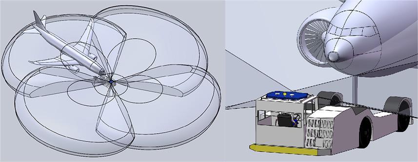
The obstacle avoidance system is installed on the aircraft towing vehicle, with a primary monitoring device being a 3D LiDAR, consisting of four LiDARs stitched together to form a 360° field of view. It provides real-time monitoring of the environment surrounding the towed aircraft. When a target object enters the set safety zone, the system triggers an alert. The alert information is conveyed through the system interface and speakers.
1. 360° Surrounding Monitoring
During ground towing by the towing vehicle, as the aircraft body is relatively large and the system's sensing devices are deployed on the towing vehicle, achieving full coverage of the entire aircraft body and leaving a monitoring area of over 200m requires high range 360° stitching to meet monitoring range requirements.
Based on the high-performance 3D LiDAR from Benewake, the solution offers a wide field of view and high range capabilities. By stitching together four LiDARs, it can cover a monitoring area of over 300m in 360°, effectively covering the monitoring range of different aircraft models. It ensures coverage of over 200m monitoring range around the aircraft regardless of straight-line movement or turning.
2. Adaptive Safety Zone
During towing and turning, the towing vehicle and aircraft form different angles, causing the LiDAR's field of view to shift. However, the aircraft safety zone needs to remain fixed. Hence, relative angle data between the towing vehicle and the aircraft is required to dynamically adjust the safety zone, ensuring its position remains fixed.
Based on the high-performance 3D LiDAR from Benewake, the collision avoidance system incorporates 3D model data of the towed aircraft. It precisely understands the outline of the aircraft. After loading, the LiDAR analyzes the point cloud data of the aircraft's detection, capturing identical feature points on both sides of the engines. Real-time data on these feature points are obtained and processed for distance, angle, and other information to calculate the relative angle between the aircraft and the towing vehicle. The monitoring safety zone adjusts accordingly based on the calculated angle values to adapt to different aircraft attitudes, meeting adaptive requirements.
3. Obstacle Recognition
Due to the complex environment of airport products, during aircraft towing, the aircraft may encounter parked aircraft, various vehicles engaged in apron operations, and ground pedestrain. With its high-resolution capability, the solution based on Benewake's high-performance 3D LiDAR can effectively recognize obstacles intruding into the safety zone. It promptly issues warnings if collision risks are detected, alerting the towing vehicle driver to apply brakes in time.

Aircraft Ground Towing Collision Avoidance system

Aircraft Ground Towing Collision Avoidance system