


Headquarters:3rd Floor, Haiguo Jiaye Sci-Tech Park, Haidian District, Beijing, China

We use cookies to enhance your browsing experience and serve personalized content.
Reject ALL
Accept ALL


2025-11-20

Slant-range measurement co-rotating with your camera. Fused with GPS and gimbal angles to output target geolocation coordinates in real time.
[Request Technical Support] [Download Product Specs]
Downward-facing LiDARs measure vertical distance to the ground. They serve altitude hold, terrain following, and hover stabilization — applications where the sensor axis is fixed and the target surface is the terrain beneath the drone.
Gimbal rangefinding is structurally different. It works by integrating a laser rangefinder (LRF) into the drone's stabilized camera system. The sensor must co-rotate with the camera, measuring slant range along the optical axis to whatever the gimbal is currently pointing at.
Benewake's gimbal LiDAR mounts alongside the camera payload and co-rotates with the gimbal, outputting continuous slant-range measurements along the optical axis. Fused with the drone's GPS coordinates, gimbal elevation angle, and azimuth, the system computes target geolocation in real time — enabling accurate object sizing, camera focus control, and target coordinate output that a downward altitude sensor cannot provide.
Camera-only systems cannot produce depth A camera outputs 2D image data only. Object size in frame is ambiguous without distance — a small object close and a large object far can occupy identical pixel areas. Measuring real-world dimensions or subject distance requires an independent ranging sensor.
Autofocus fails in low-contrast and low-light conditions Contrast-based autofocus requires sufficient image contrast to converge. In night operations, haze, or thermal imaging workflows, contrast is insufficient and autofocus fails. A gimbal LiDAR supplies focus distance directly, removing the dependency on scene contrast.
Downward-facing LiDAR cannot measure slant range A nadir-pointing altitude sensor measures vertical distance to the ground. Once the gimbal tilts, its measurement axis diverges from the camera's optical axis — the reading no longer reflects target distance. A valid slant-range measurement requires a sensor that co-rotates with the gimbal.
Sensor weight and form factor constrain gimbal design Heavier sensors shift payload center of mass, require counterweight adjustments, and reduce angular velocity. Bulky form factors physically limit the gimbal's range of motion. Both increase integration complexity and reduce overall payload efficiency.
Benewake LiDAR is integrated into the Gimbal, enabling precise target acquisition and tracking through real-time distance measurement. By fusing the drone’s GPS coordinates with LiDAR-derived distance, elevation angle, and azimuth data, the system employs triangulation to determine the object’s geolocation with high accuracy.
Address Endurance and Insufficient Space Lighest design as 5g with Compact Siz | Enhanced Operational Accuracy Kilometer-level Range: +100m Range → Higher Accuracy | Quick System Setup Plug-and-Play Testing with Mainstream Flight Controllers; Reduced Pre-Deployment Efforts |
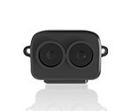
From 5 g — Minimal Payload Impact TF-Luna weighs under 5 g; TFA series sensors are 11 g. All three add negligible mass to the gimbal payload. Three mounting points allow precise optical-axis co-alignment with the camera.
Up to 1500 m Slant Range TF-Luna covers 0.2–8 m for close-range applications; TFA1200-L reaches 1200 m and TFA1500-L up to 1500 m for standoff surveillance, ISR, and border monitoring use cases.
Real-Time Slant-Range Output The sensor outputs distance along the gimbal's optical axis — the ranging input required for target geolocation computation and AI object sizing pipelines. Update rate: up to 250 Hz (TF-Luna), up to 800 Hz (TFA1500-L), 3 Hz (TFA1200-L).
LiDAR-Assisted Camera Focus Slant-range data is passed directly to the camera focus controller, enabling focus-by-distance independent of scene contrast. Effective in low-light, haze, and thermal imaging conditions.
UART / I²C Interface TF-Luna supports UART, I/O, and I²C. TFA series supports UART. Compatible with PX4, Ardupilot, and major flight controllers including PixHawk, Cube, and CUAV series.
Search and Rescue Precision Target Localization Gimbal integration allows sensors to pivot and lock onto specific targets in complex terrain providing exact 3D coordinates and distance data for rapid emergency response.
Law Enforcement & Border Security Delivers precise distance measurements to intruders, vessels, or vehicles across border patrols, port, and airport security operations. Range data supports incident documentation and forensic analysis.
Aerial Photography & Videography LiDAR-fed focus control keeps the camera locked on moving or variable-distance subjects without contrast-based autofocus hunting. Maintains sharpness during dynamic tracking shots regardless of lighting conditions.
Not sure which sensor fits your system?
Every platform has different range, weight, and interface requirements. Contact our technical team and we'll help you identify the right sensor for your UAV and operating environment.[Contact Us]
Why UAV developers choose Benewake for terrain sensing?
Since 2016, Benewake has specialized in single-point Time-of-Flight LiDAR for industrial and commercial applications. Our sensors have been adopted by UAV manufacturers and system integrators across agriculture, inspection, delivery, and security sectors globally.
We design sensors specifically for the constraints of UAV integration — minimal weight, robust field performance, and broad compatibility with the platforms and tools that engineers already use. Beyond hardware, we provide datasheets, integration guides, and technical support to help development teams move from sensor selection to working system as efficiently as possible.
[Contact Support] [About Benewake]
Logistic Drone Read More |