


Headquarters:3rd Floor, Haiguo Jiaye Sci-Tech Park, Haidian District, Beijing, China

We use cookies to enhance your browsing experience and serve personalized content.
Reject ALL
Accept ALL


2025-11-24

Maintain precise, consistent height above ground throughout your entire flight path — regardless of terrain variation, speed, or GPS limitations. Benewake LiDAR gives moving UAV systems the real-time AGL reference they need to hold altitude accurately from takeoff to landing.
[Request Technical Support] [Download Product Specs]
Altitude control is the flight mode in which a UAV maintains a target height above ground level (AGL) while in motion — advancing, reversing, or turning across a mission area. Unlike hovering, the drone is continuously moving; the flight controller's job is to hold the Z-axis stable while the platform travels horizontally across varying terrain.
This is fundamentally a real-time sensing and correction problem. As terrain rises and falls beneath a moving drone, the system must continuously measure the actual distance to the ground and feed that data to the flight controller — which adjusts motor output to compensate before altitude error accumulates.
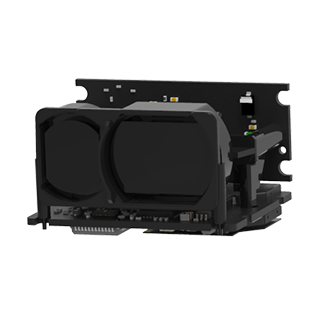
Benewake single-point LiDAR operates on the Time-of-Flight (ToF) principle: a laser pulse is emitted downward, reflects off the surface, and returns to the sensor. The elapsed time determines the precise ground distance. This measurement is output at high frequency — up to 1000Hz — via standard interfaces (UART, I²C, CAN) directly into the flight controller's altitude control loop.
GPS altitude diverges from ground distance in motion GPS reports height above sea level, not above the surface below. On undulating terrain, the two values decouple — and the drone climbs or descends relative to the ground without knowing it.
Barometers are vulnerable to forward-flight disturbance At cruising speed, airflow across the fuselage creates pressure variation that barometric sensors cannot distinguish from genuine altitude change. The faster the drone flies, the less reliable barometric AGL feedback becomes.
Terrain changes faster than slow sensors can report At typical spray or survey speeds, terrain elevation can shift significantly between sensor readings. A slow sensor always reports where the ground was — leaving the flight controller correcting errors that have already grown.
Surface transitions disrupt sensor output A single mission may cross grass, gravel, asphalt, and crop canopy. A sensor that performs well on one surface may spike or drop on another, creating instability in the altitude loop precisely when it matters most.
Weight directly costs endurance and payload Every gram added to the sensor stack is subtracted from battery life or useful payload. A terrain-sensing solution too heavy to deploy practically is not a solution.
Benewake LiDAR is integrated with altimeters (e.g., GPS, barometer) via data fusion, delivering more precise ground altitude measurement. Extended ranging capacity enables UAVs to maintain centimeter-level stability in cruise and hover above 200m; higher operational altitude expands mission coverage.
Adapt to higher-speed drone cruising.Measure altitude at a high frequency of 10KHz, 10,000 times per second. | Address Endurance and Insufficient SpaceLighest design as 5g with Compact Size | Quick System SetupPlug-and-Play Testing with Mainstream Flight Controllers; Reduced Pre-Deployment Efforts |
Direct, Motion-Independent Ground Reference Measures line-of-sight distance to the surface continuously, regardless of forward speed. GPS elevation and barometric drift are removed from the altitude control loop entirely.
High-Frequency Output Matched to Cruising Speed Up to 1000Hz update rate means altitude data reaches the flight controller faster than terrain changes beneath a moving drone. The system reacts to where the ground is now.
Consistent Output Across Surface Transitions Built-in anti-interference processing maintains stable readings across grass, asphalt, concrete, and crop canopy — through sunlight, dust, and light rain — without dropouts at surface boundaries.
Extended Range for High-Altitude Missions Long-range Benewake models support accurate altitude measurement beyond 200m AGL, expanding the operational envelope for survey and wide-area inspection missions.
UAV-Native Form Factor Compact and lightweight — down to 5g — with low power draw. Adds AGL sensing without meaningfully affecting endurance or payload capacity.
Broad Flight Controller Compatibility Compatible with standard interfaces and leading open-source flight controllers including PX4, ArduPilot, iNav, and Betaflight.
Aerial Survey & Photogrammetry Ground sampling distance is a direct function of sensor-to-surface altitude. Benewake LiDAR gives mapping platforms a stable ground reference throughout the flight, supporting the consistent altitude that accurate photogrammetry requires.
Infrastructure Corridor Inspection Roads, pipelines, and power lines follow terrain that rises and falls continuously. Benewake LiDAR supports inspection UAVs in maintaining a stable sensor-to-target distance along the full corridor.
Long-Range Mission Coverage Extended-range Benewake sensors enable high-altitude cruising where maintaining AGL accuracy across large, varied areas is the core operational requirement.
Not sure which sensor fits your system?
Every platform has different range, weight, and interface requirements. Contact our technical team and we'll help you identify the right sensor for your UAV and operating environment.[Contact Us]
Why UAV developers choose Benewake for terrain sensing?
Since 2016, Benewake has specialized in single-point Time-of-Flight LiDAR for industrial and commercial applications. Our sensors have been adopted by UAV manufacturers and system integrators across agriculture, inspection, delivery, and security sectors globally.
We design sensors specifically for the constraints of UAV integration — minimal weight, robust field performance, and broad compatibility with the platforms and tools that engineers already use. Beyond hardware, we provide datasheets, integration guides, and technical support to help development teams move from sensor selection to working system as efficiently as possible.
[Contact Support] [About Benewake]
Logistic Drone Read More |