


Headquarters:3rd Floor, Haiguo Jiaye Sci-Tech Park, Haidian District, Beijing, China

We use cookies to enhance your browsing experience and serve personalized content.
Reject ALL
Accept ALL


2025-11-24

Achieve precise altitude control and stable flight in challenging conditions with Benewake’s LiDAR technology for drones. Designed for seamless integration, our LiDAR ensures accurate terrain tracking, even in rain or fog, boosting efficiency in agriculture, surveying, and more.
Request Technical Support;Download Product Specs
Terrain following is a UAV capability that allows a drone to maintain a constant height above ground level (AGL), dynamically adjusting as the terrain rises and falls beneath it — rather than holding a fixed GPS elevation.
Benewake single-point LiDAR operates on the Time-of-Flight (ToF) principle: a laser pulse is emitted downward, reflects off the surface, and returns to the sensor. By measuring the time elapsed between emission and return, the sensor calculates the precise distance to the ground. This process repeats at high frequency, producing a continuous stream of real-time distance measurements.
The distance measurements are output via standard communication interfaces (UART, I²C, CAN, etc.) to the flight controller. The flight controller compares the incoming AGL reading against the target altitude set by the mission. When terrain rises, the measured distance decreases, prompting the controller to command a climb; when terrain drops, it commands a descent. This closed-loop correction runs continuously throughout the flight, allowing the UAV system to contour the terrain in real time.
GPS altitude ≠ ground altitude GPS measures height above sea level, not above the surface directly below. As terrain rises and falls during flight, the gap between GPS elevation and actual ground distance changes constantly — making GPS-referenced altitude control fundamentally unsuitable for terrain-adaptive flight.
Barometers can't keep up in motion Barometric sensors can drift under airflow disturbance and pressure changes generated by forward flight. At speed, even small measurement lags can translate into altitude errors that accumulate faster than the flight controller can correct.
Diverse and unpredictable surface types Grass, asphalt, concrete, water, gravel — each reflects laser energy differently. A sensor stable on one surface may spike or drop on another, disrupting the altitude control loop precisely when terrain transitions demand the most from it.
Sensor response needs to outpace terrain change At typical survey or spray speeds, terrain can rise or fall faster than a slow sensor can report. If the altitude update rate doesn't exceed the rate of terrain change, the drone is always reacting to where the ground was — not where it is.
Weight and power constraints Every gram added costs flight time and payload capacity. A terrain sensing solution that adds meaningful weight directly shortens the mission it is meant to enable.
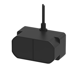
Benewake LiDAR is integrated into UAVs with downward-mounted configuration, tracks terrain variations; Terrain Following/Awareness capability ensures optimal altitude maintenance in agriculture, surveying, etc.
Avoid fuselage jitter and greatly reduce damage.Measure with centimeter-level accuracy and integrate special rain and fog algorithms. | Address Endurance and Insufficient SpaceLighest design as 5g with Compact Size | Quick System SetupPlug-and-Play Testing with Mainstream Flight Controllers; Reduced Pre-Deployment Efforts |
Direct Ground Reference Measures line-of-sight distance to the surface — independent of GPS or barometric pressure — giving the flight controller a reliable real-time AGL input across varied environments.
Consistent Across Surface Types Built-in anti-interference processing maintains stable output across grass, asphalt, concrete, and mixed terrain — in sunlight, dust, and rain.
High-Frequency Output Up to 1000Hz update rate ensures altitude data reaches the flight controller faster than terrain changes beneath a moving drone — the system reacts to where the ground is, not where it was.Lightweight, UAV-Native Design Compact and light, with low power draw. Designed to integrate cleanly into UAV platforms where payload and endurance are tightly managed.
Broad Platform Compatibility Compatible with mainstream communication interfaces and leading open-source flight controllers including PX4, ArduPilot, iNav, and Betaflight.
Aerial Survey & Mapping Accurate UAV height measurement is fundamental to photogrammetry quality. Benewake LiDAR gives mapping systems a direct ground reference, helping maintain the sensor-to-surface distance that accurate photogrammetry requires.
Infrastructure Inspection Roads, pipelines, and power lines follow the landscape. Drone height measurement from from Benewake LiDAR supports inspection systems in holding a stable sensor-to-target distance throughout the flight path.
Autonomous Delivery & Landing Reliable descent requires real drone terrain awareness, not an estimated GPS elevation. Benewake LiDAR provides the real-time distance input that delivery UAV systems use to guide controlled, stable landings on varied surfaces.
Not sure which sensor fits your system?
Every platform has different range, weight, and interface requirements. Contact our technical team and we'll help you identify the right sensor for your UAV and operating environment.[Contact Us]
Why UAV developers choose Benewake for terrain sensing?
Since 2016, Benewake has specialized in single-point Time-of-Flight LiDAR for industrial and commercial applications. Our sensors have been adopted by UAV manufacturers and system integrators across agriculture, inspection, delivery, and security sectors globally.
We design sensors specifically for the constraints of UAV integration — minimal weight, robust field performance, and broad compatibility with the platforms and tools that engineers already use. Beyond hardware, we provide datasheets, integration guides, and technical support to help development teams move from sensor selection to working system as efficiently as possible.
[Contact Support] [About Benewake]
|
|
Logistic Drone Read More |