


Headquarters:3rd Floor, Haiguo Jiaye Sci-Tech Park, Haidian District, Beijing, China

We use cookies to enhance your browsing experience and serve personalized content.
Reject ALL
Accept ALL


2025-11-24

Keep your UAV at a precise, stable altitude — resistant to rotor downwash, airframe vibration, and environmental disturbance — with Benewake LiDAR delivering the real-time height reference your flight controller needs. Designed for UAV platforms where exact vertical positioning is critical to mission success.
[Request Technical Support] [Download Product Specs]
Position hold — sometimes called hovering — is the flight mode in which a UAV maintains a fixed point in three-dimensional space: no lateral drift, no yaw movement, and no vertical displacement. Unlike altitude-control cruising, where the drone is actively moving and the controller tracks terrain below, position hold asks the system to resist all forces acting on it and stay exactly where it is.
Holding a stable three-dimensional position requires the flight controller to manage X, Y, and Z simultaneously. Lateral stability is typically handled by GPS and optical flow. Vertical stability — holding a precise, fixed height — requires a reliable, real-time altitude reference that does not drift, lag, or degrade under the airflow conditions a hovering UAV generates.
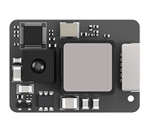
Benewake single-point LiDAR measures the direct distance from the drone to the surface below using Time-of-Flight (ToF) sensing. That distance is output continuously at high frequency via UART, I²C, or CAN directly to the flight controller. The controller uses this live AGL input to detect and correct any vertical displacement in real time — maintaining the locked Z-axis position that precision hovering demands.
Barometers drift under rotor downwash A hovering drone creates a concentrated pressure field directly below its rotors. Barometric sensors cannot separate this rotor-induced disturbance from genuine altitude change, producing continuous low-level vertical oscillation.
GPS vertical accuracy is insufficient for precision hold Horizontal GPS accuracy is typically within a few meters; vertical accuracy is worse. For close-range inspection or payload delivery, GPS altitude is not a reliable Z-axis reference.
Vibration corrupts inertial altitude estimates Motors, props, and airframe resonance generate mechanical vibration that IMU-based altitude estimation accumulates as error over time — causing held altitude to drift even when the drone appears stationary.
Wind gusts create displacement that must be corrected immediately A strong gust can push a hovering drone vertically before the flight controller responds. The slower the altitude feedback loop, the greater the displacement before correction — and the more disruptive the recovery maneuver.
Precision hovering applications demand small error margins Blade inspection, close-range imaging, and sensor-to-target measurement all require the drone to hold position within a narrow vertical tolerance. Imprecise altitude feedback means imprecise position — and imprecise data.
Stable Z-Axis Reference Independent of Rotor Downwash LiDAR measures direct distance to the surface — unaffected by rotor-induced pressure disturbance. The flight controller receives a clean, drift-free altitude signal even under demanding hover airflow conditions.
Benewake LiDAR can be integrated flexibly with UAVs in downward/forward/bi-directional configurations, enabling safe-distance flight from specific objects. It operates standalone or combined with optical flow sensors for precision hovering at preset altitudes. Widely deployed in industrial UAVs (e.g., wind turbine blade/power line inspections). During aerial imaging, it synchronously measures ground distance while ensuring forward-flight stabilization.
Avoid fuselage jitter and greatly reduce damage.Measure with centimeter-level accuracy and integrate special rain and fog algorithms. | Address Endurance and Insufficient SpaceLighest design as 5g with Compact Size | Quick System SetupPlug-and-Play Testing with Mainstream Flight Controllers; Reduced Pre-Deployment Efforts |
High-Frequency Output for Tight Vertical Control Up to 1000Hz update rate means vertical displacement is detected and corrected before it compounds. The flight controller works with current altitude data, enabling tighter, more responsive Z-axis hold.
Consistent Performance Across Hold Surfaces Built-in anti-interference processing maintains stable output over grass, concrete, asphalt, and mixed surfaces — in sunlight, dust, and light rain — wherever the UAV holds position.
Complements Optical Flow for Full 3D Position Lock Benewake LiDAR handles Z; optical flow handles X/Y. Together, they give the flight controller complete spatial reference for reliable three-axis position hold.
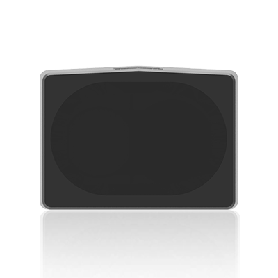
Compact and UAV-Native Down to 5g with low power consumption. Adds altitude sensing without meaningful impact to endurance, payload, or center-of-gravity management.
Broad Flight Controller Compatibility Works with PX4, ArduPilot, iNav, Betaflight, and standard UART/I²C/CAN interfaces — compatible with the platforms and tools UAV teams already use.
Delivery Drones Precise altitude hold through payload release and touchdown on varied surfaces — reducing hard landings and payload damage.
Drone Light Shows Ensures hundreds of "aerial pixels" maintain rock-solid 3D positions. Precise hovering enables complex formations, prevents mid-air collisions, and keeps synchronized visual patterns sharp from the ground.
Infrastructure Inspection Holds a consistent distance from wind turbine blades, power lines, and bridges — enabling stable, close-range positioning.
Security & Patrol Drones Maintains precise altitude hold independently of GPS — keeping patrol UAVs locked on-station in urban canyons and high-interference environments.
Not sure which sensor fits your system?
Every platform has different range, weight, and interface requirements. Contact our technical team and we'll help you identify the right sensor for your UAV and operating environment.[Contact Us]
Why UAV developers choose Benewake for terrain sensing?
Since 2016, Benewake has specialized in single-point Time-of-Flight LiDAR for industrial and commercial applications. Our sensors have been adopted by UAV manufacturers and system integrators across agriculture, inspection, delivery, and security sectors globally.
We design sensors specifically for the constraints of UAV integration — minimal weight, robust field performance, and broad compatibility with the platforms and tools that engineers already use. Beyond hardware, we provide datasheets, integration guides, and technical support to help development teams move from sensor selection to working system as efficiently as possible.
[Contact Support] [About Benewake]
Logistic Drone Read More |